Thank you to R. David Adams for submitting these photos of the Fairview Lift Bridge and the accompanying Cartwright Tunnel, between Cartwright, North Dakota and Fairview, Montana. This bridge is frequently confused with the Snowden Bridge, a few miles away in Montana, partly due to a similar history (each bridge has only been raised once) and construction. However, this bridge is distinct from the Snowden bridge when the Cartwright tunnel is taken into account. To our knowledge, the tunnel is the only train tunnel in the state of North Dakota.
As you’ll learn from Mr. Adams’ comments below each photo, this lift bridge was built to accommodate steamboat traffic on the Yellowstone River, but the steamboats stopped steaming the Yellowstone River before the bridge was complete. Thus the lift was only used one time. The last car crossed the bridge in 1955, and the trains ended in the 1980’s. Since the bridge and tunnel were so narrow, travelers were required to pick up a phone at one end and call to ensure no traffic was coming from the other side!
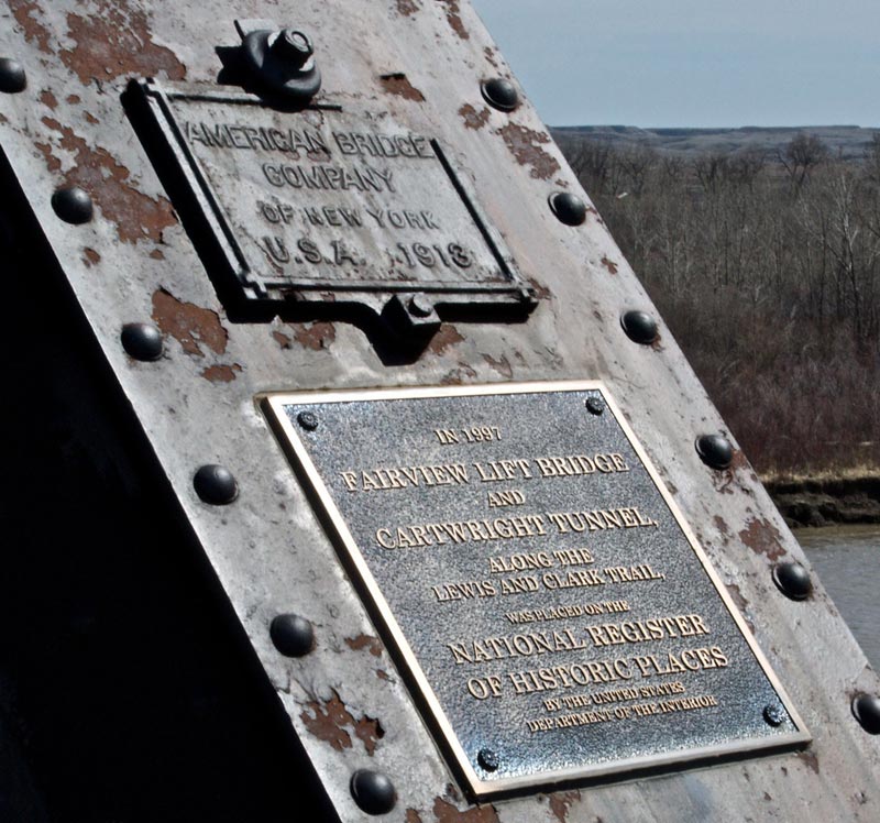
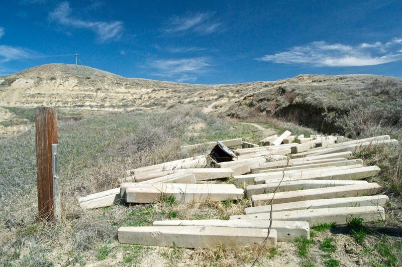
On ramp west end of Fairview Lift Bridge just a couple of miles East of Fairview Montana. This Bridge was finished in 1913 and was a bridge used for rail and automobile traffic until 1955.
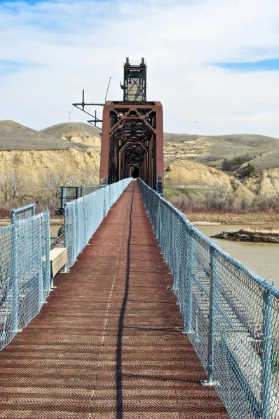
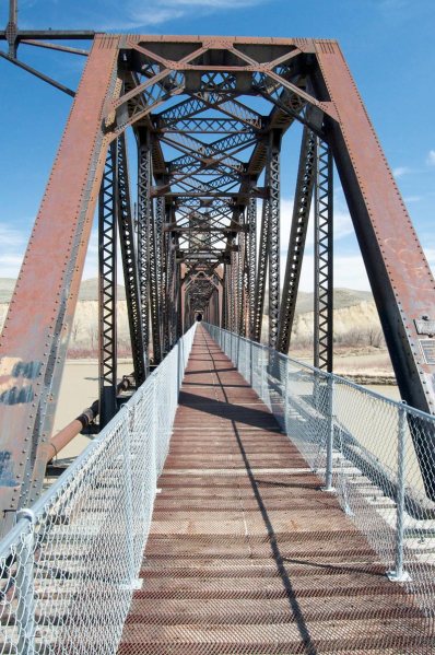
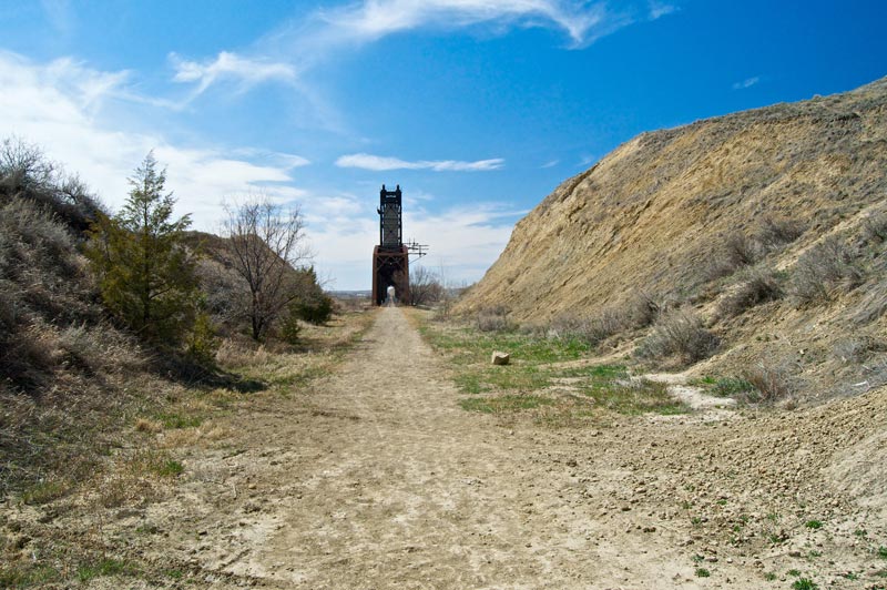
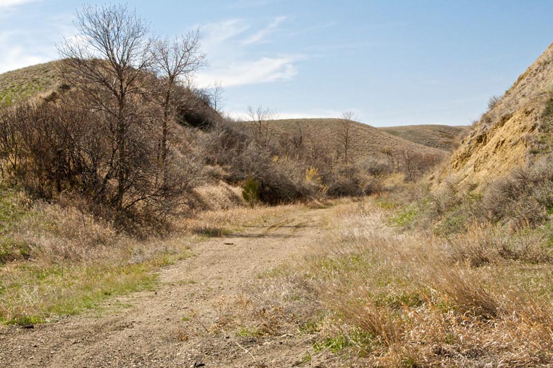
Looking east as we walk on the rail bed. You can see the Cartwright tunnel at the end of the bridge.
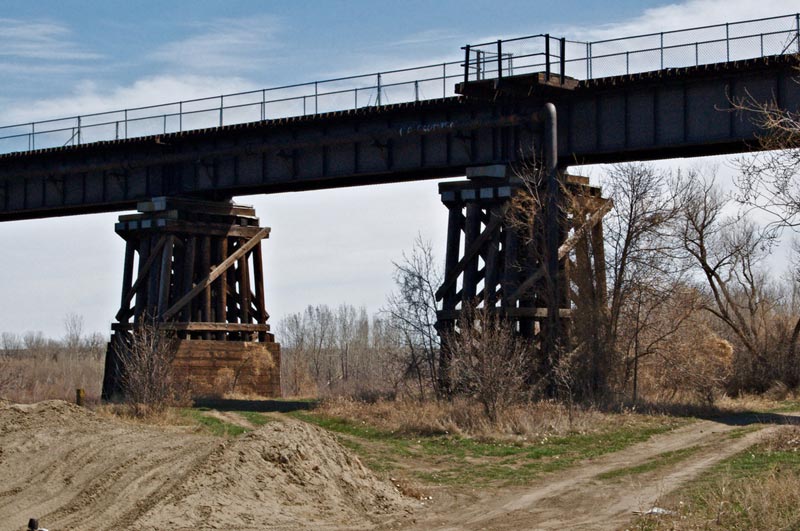
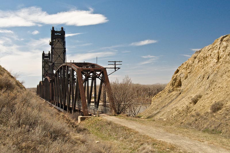
Approaching the bridge support from the west looking east.
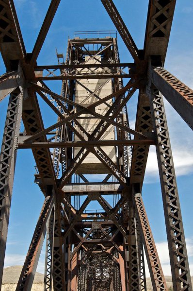
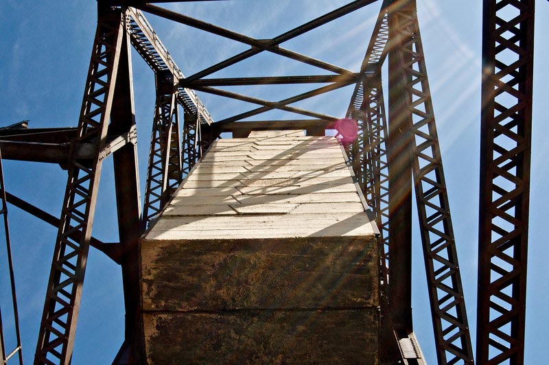
The center section or “draw” weighs in at 1.14 Million Pounds. At each end of the span large concrete counterweights are hung to assist in the lifting of the span.
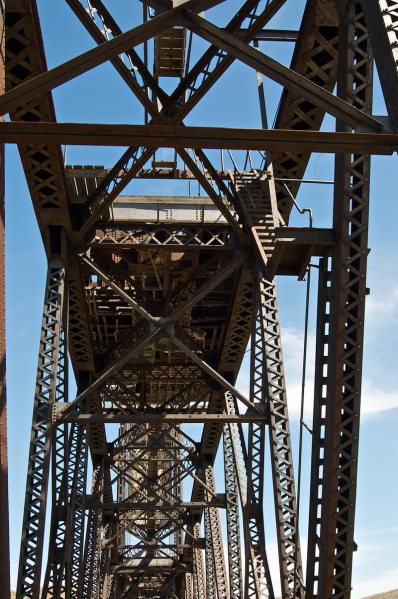
Platform that contains a three cylinder kerosene engine that lifts the bridge span.
Closer look at the lift mechanism. this lift operated one time to test the bridge and never again. It seems that steamship travel on the Yellowstone ended during the construction of the bridge in 1912!
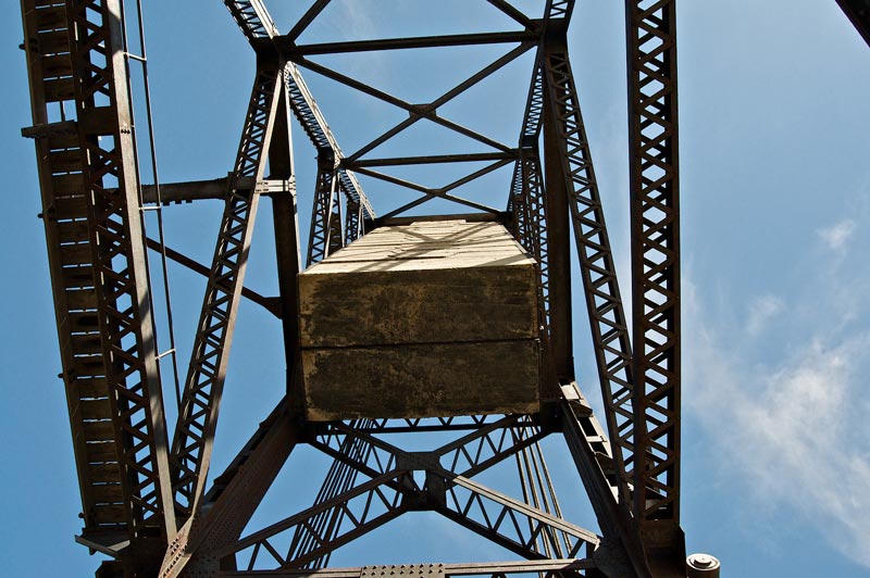
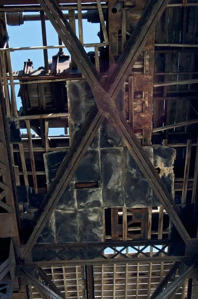
Looking up at one of the two counterweights. Held up by several 2 inch cables. I was thinking they have been there for almost a hundred years and decided to move… just in case!
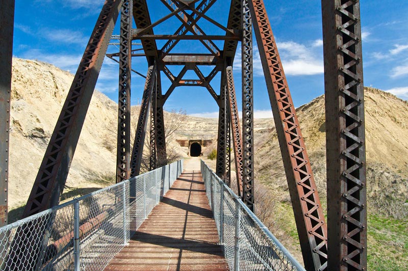
On the east end approach showing the west tunnel opening.
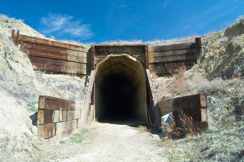
Notice the size of the treated lumber used around the opening! Cars traveled across the top to gain access to the bridge on the right just behind where I was standing.
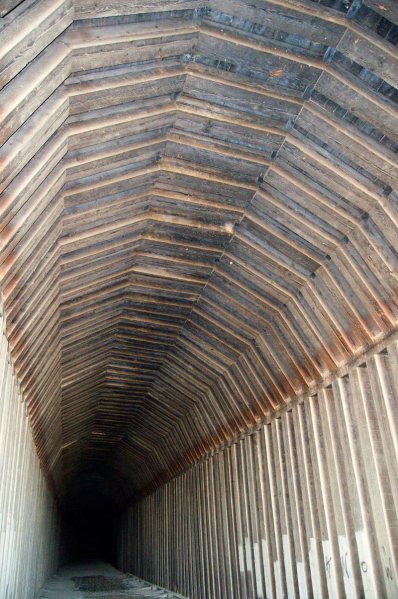
Inside the tunnel.
The road that used to allow cars to use the bridge until 1955. right behind me the road slopes down to the bridge and also branches off to get down to the bridge abutments.
Looking west from the tunnel to the bridge.
Looking west.
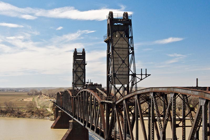
I climbed up the small hill on the south of the rail bed to get a better picture of the engine and tower houses that move the center span of the bridge up and down.
Just around the bend is the east entrance to the Tunnel but is now on private lands. Cartwright is just a mile to my back. To read more about this bridge, visit this site.
All photos by R. David Adams, copyright RDA Enterprises. Original content copyright Sonic Tremor Media LLC

I have a picture of this bridge as my wallpaper on my laptop. I graduated from Fairview High School and have always been fascinated by this bridge. I have never walked through the tunnel but coming home this summer and that’s the one thing on my list!
LikeLike
Another location on the list of places I want to get to. Beautiful pics and tantalizing hints of what else is just around the corner.
Thanks for posting them
Tom
LikeLike
Beautiful pictures! We visited the bridge last summer but I only got partway across before turning back. Nice to see the rest of it!
LikeLike
I WAS 8-9 YEARS OLD WHEN WE CROSSED TO VISIT THE REST OF OUR FAMILY IN WATFORD CITY. I REMEMBER THAT BRIDGE THE TRAINS AND THE WATER. WHAT A TREAT AFTER ALL THESE YEARS. THANK YOU.
LikeLike
That would make a great bike trail!
LikeLike
Great pictures, been on the bridge many of times. Great time to visit is during paddlefishing season…..The place is crazy with people. great place to camp a weekend too.
LikeLike
Just up the river a few miles in Montana is another lift bridge. Nohle(sp) bridge. Another great landmark and piece of history.
LikeLike
actually it is down the yellowstone river app. 10-12 miles then up the missouri app 4-5 miles
LikeLike
There are two bridges. One up the Missouri and one up the Yellowstone. The one up the Missouri is called the “Snowden” or “Nohly Bridge” by locals. This is the Yellowstone Bridge. I have climbed to the top of both bridges in my youth.
LikeLike
Can’t believe David beat me to it posting these pictures. I dug out my pictures of the bridge and haven’t gotten a chance to scan them yet. I was Sheriff in McKenzie Co from 74-79. I think it was known as the Snowdon Bridge by locals, but I don’t know the origin of that name. I’d never heard it called the Fairview Lift Bridge. Quite the structure to be used for cars, trains and steamboats. With the fur trade, Lewis and Clark, the military forts, Indian Wars and steamboats there is so much history within 10 miles of this spot.
LikeLike
Jim, The snowden bridge goes over the Missouri a about 8 miles from this bridge. It was called Snowden as there used to be a town there… and also called the Nohley Bridge as that used to be a town there also.
LikeLike
The Snowden Bridge is actually about ten miles away, a twin to this bridge.
LikeLike
You are absolutely right. The more I thought about it in relation to the Cartwright Tunnel, I knew I was wrong. The Fairview bridge could be seen from the highway as you came down into the Yellowstone River bottoms from Cartwright. There used to be a large park on the South side of the highway next to the bridge.The Hurleys lived on the North side. I knew I remembered driving across the Snowden Bridge in the 70’s but I heard it was going to be torn down. It was a sister bridge in that it too had a section which could be raised for steamboats. Now you’ve given me incentive to scan my pictures and send them to you.
Thanks
LikeLike
I’m pretty certain that the Snowden Bridge is still being used by Burlington-Northern-Santa Fe Railroad company.
LikeLike
That is correct. Snowden is still used, Fairview is not.
LikeLike
I live in fairview, and the floods of the Missouri are threatening this piece of history.
The high waters and heavy currents have caused at least one of the pillars to start to crack, and rather badly at that, and the tunnel is suffering damage from the super wet year we have had.
and @ghostsofnorthdakota.com, snowden is still used, but only for train traffic, and it’s being used heavily.
LikeLike
I love this website, and visit every now and then for updates. I’ve never been to North Dakota, and since becoming a visitor I would like to someday.
I’m originally from Nebraska, and we have our own ghost towns as well. Here is a recent article on Nebraska’s ghost and nearly ghost towns:
http://journalstar.com/news/state-and-regional/nebraska/article_87d233f2-b7e1-50b9-8a57-2e6dbe8fb4ed.html
LikeLike
I worked on the Fairview bridge in the early 1950’s as a relief leverman-telegrapher for the Gt Northern Railway. There was a boxcar sized office on the east end of the bridge on the north side of the tracks. One daily passenger train, and a tri-weekly freight. The local folks all knew the set up as far as driving on the railway bridge which was shared by the highway. Once in a while, you would get an out-of-stater driving thru, and you would come out of the office and flag them thru the bridge. In the 1930’s this was a toll bridge for highway traffic, but the state of North Dakota finally came in and made if a free bridge. Sometime in the 1930’s , I remember being on a hunting trip with my Dad on a Sunday morning. The driving approach/exit on the west end was a lot farther west at that time. The gate was controlled by the leverman in the office, and it was locked. After a lot of cranking on the old magneto phone, my Dad finally got a wrench out of his pickup, took the gate down, drove the pickup thru, replaced the gate, and crossed the bridge. No one to be seen at the office. Self-service, it’s known as now days.
Don from Minot
LikeLike
I’ll be heading to North Dakota in may and want to check out this bridge. What’s the best way to access it?
LikeLike
David, just head west from Cartwright on Highway 200. Cross the river on the highway bridge and turn left (south) on the far side of the river into an informal park. The lift bridge parallels the highway bridge.
LikeLike
This bridge is amazing!!! i have never seen anything like it….i chickened out trying to cross from west side(i’m terrified of hieghts, lol) but am going to do it on my return trip. thank you for sharing your pictures and some of its history.
LikeLike
I am scared of height but I have crossed it twice. It is fun.
LikeLike
How long is the tunnel? Can you walk/bike through it?
This reminds me of the summer days I would spend with my dad. We would get topographical maps from the US Geological Survey office and go out in search of abandoned rail lines and tunnels in central Pennsylvania. Loads of fun.
This is the second article on this website I’ve read and you now have me hooked. Love it!
LikeLike
The tunnel is about 1/4 mile in length. It is curved, one end is 3 degrees from the other, so therefore, there is a dark place in the middle. A flashlight is recommended. It is open to pedestrian traffic, as well as bicycles and horses.
LikeLike
I have walked the bridge several times. My favorite is to walk it at night. Bring flash lights and some good company and walk the tunnel. I recently moved back to Oregon from Williston, this was one of my things I did before I left.
LikeLike
hey does anyone know how high the bridge is off the river? ..i believe the tunnel side of the bridge seems higher and i understand that the river levels are never constant.
LikeLike
As has been said the Snowden bridge is a few miles from here in Montana on the Missouri river. It too carried auto traffic and did so until the early 1990s. Like the Fairview bridge it too has only been raised once,to allow a barge to go up river for the construction of Fort Peck Dam. At that time the bridge was old enough that the power system to lift the bridge was not in operating condition so they attempted to use the man powered emergency system where 4 men would walk in a circle pushing on bars to rotate a center hub which would raise the bridge.They turned on it all day and got it up about 6 ft, When the barge arrived they found that there was no need to raises it at all. The Snowden bridge Still carries railroad traffic today!
LikeLike
Must ride to view this location!
LikeLike
Look at how the inside of that tunnel is built! Amazing. Why was it closed?
LikeLike
I have identical pictures of the bridge and tunnel. No, I haven’t made it to the other side! Last time I was there, I attempted to follow my husband through, complete with an entourage of biting hoards of mosquitos! It was so black, even in the middle of the day! My husband brought us there as newly-weds back in 1998, that was also our daughter’s first trip, she would be born 2 months after the paddlefishing season ended. A beautiful place to camp or picnic too!
LikeLike
Why would such a large bridge AND tunnel be constructed to get a relatively short line into Watford City the hard and expensive way? So looking into the history of the Great Northern RR, I did find that building this line implied that management maybe was starting construction of a second main line, from New Rockford in ND to Lewiston Montana. But it looks like plans changed quickly! And the Board of Directors probably sent whoever authorized that construction looking for employment elsewhere.
LikeLike
Short story for the reason for both Fairview and Snowden bridges is thus. Great Northern RR and Northern Pacific RR were in direct competition for fastest route from Chicago to Seattle/Tacoma WA areas. Great Northern decided to make a cut off from the normal route Fargo-Grand Forks-Minot-Williston and decided to build going NW from Fargo to New Rockford, then west going to the Missouri River valley near where Elbowoods ND once was. Then cross the Missouri west of Elbowoods near where the Little Missouri/Missouri confluence was and follow a creek up to Watford City and west to this and the Snowden bridges to rejoin the mainline at the Snowden siding. Building on this shorter route began, but then World War I came along. And a steel shortage that prevented Great Northern from finishing this route. After the war, it was never completed. Thus the short line to Watford City was the only complete part of what had been planned of a much larger new route.
LikeLike
As a youngster, I crossed many times as a passenger on the combo bridge used by autos and trains alike. Approaching from the Fairview side (west) we’d see a traffic light that would hold us on the red if a train was coming through the tunnel. Nevertheless, never once did I trust the light and always anticipated a train would roar out of the tunnel when we were halfway across the bridge. Dave Erickson
LikeLike
Me and my son visited it last summer, walked through the tunnel.. It is awesome pictures do not show the workmanship on the bridge its self.
Do bring flashlights, the tunnel is dark and kind of spooky, but way cool.. Literally cool, might want a light jacket for children..
Had driven by this a thousand times, very glad that we stopped and saw it. The historical history upon the workmanship make it a great visit, easy access , great information boards around it.
LikeLike
My Dad, Roy Loe, has told many stories of standing in that tunnel as a kid in the 50’s and bracing against the wall while the trains roared through. He has brought me and the Grandkids there several times and sat at the tunnel entrance and reminisced about his childhood in Fairview.
LikeLike
In the 90’s when I went to school in Sidney, we came here to drink beer. I remember that up on the side of the hill about 100 or so feet before the tunnel, was a small hole that you could crawl back in, actually had 4 or 5 rooms back in it. I always wondered if this was an abandoned mine or something else. I had heard they might have dynamited it?
LikeLike
Interesting. Sounds like a fine night excursion!
LikeLike